By Brendan O’Connell
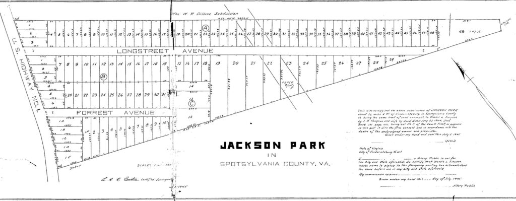
Jackson Park is a triangular-shaped subdivision located along Lafayette Boulevard, south of Fredericksburg’s downtown. It is the city’s southernmost subdivision. Local surveyor, L. R. R. Curtis, platted the subdivision in August 1945, dividing the approximately 32-acre tract into 114 individual building lots.1 Bessie L. Simpson and her husband, W. H. Simpson, established Jackson Park, although they lived in the Kenmore subdivision, another racially restricted neighborhood in Fredericksburg.2 Bessie Simpson was a teacher, and W. H. Simpson owned a lumber mill where their son, Larry, was also employed.3
Figure 1: Jackson Park Subdivision Plat Map Drawn by L. R. R. Curtis, 1945. Courtesy, Spotsylvania County Courthouse.
Bessie L. Simpson and her husband sold off parcels in the Jackson Park subdivision to individual homebuyers until W. H. Simpson’s death in 1949.4 Following his passing, Bessie continued selling parcels on her own. Between the subdivision’s inception in 1945 and through the March 1952 sale to Lewis Wallace Powell, all property deeds included racially restrictive covenants.5 The next lot, sold in August 1952 to the DeBrain family, did not have any racial restrictions.6 The reason for this change is unclear, but it may have been a response to the 1948 Shelley v. Kraemer Supreme Court decision, which prohibited courts from enforcing racially restrictive covenants.7
Interestingly, the first three deeds sold in Jackson Park included covenants that were to be enforced for 99 years, while all subsequent restricted parcels were sold with 50-year terms. Although the reason for this change is uncertain, it is likely an attempt to comply with the Rule Against Perpetuities (RAP), a legal doctrine designed to prevent covenants from binding land indefinitely. Had Shelley v. Kraemer (1948) and the Fair Housing Act (1968) not occurred, those initial 99-year covenants would still be legally binding today.
After Bessie L. Simpson’s death, the remaining parcels in Jackson Park were deeded to her son, Larry Simpson, and his wife, Peggy Simpson. These remaining unsold parcels were later sold to Joseph Boggs, who re-subdivided them into the Confederate Ridge subdivision. Like Jackson Park after March 1952, this new subdivision did not include racially restrictive covenants. Its name, however, telegraphed to prospective homebuyers that it also was a white-only neighborhood.
Racially restrictive covenants, in a fundamental sense, work to control where people can and cannot live in a given place. They not only maintain racial boundaries but also create new ones by declaring certain spaces as white only. Such boundaries, commonly referred to as the “color line,” served to separate and contain Black communities, reinforcing social and economic divisions along racial lines. The implementation of racially restrictive covenants in Jackson Park followed this same pattern.
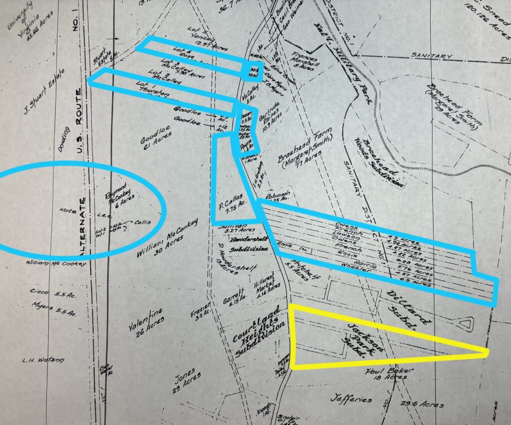
Figure 2: Section of the Johnson & Williams Consulting Engineers Map of the Courtland Magisterial District, 1954. The Jackson Park Subdivision shown in yellow, and known Black owned properties shown in Blue. Courtesy, Spotsylvania County Courthouse.
Located less than a quarter mile south along Lafayette Boulevard from a significant area of Black-owned properties, Jackson Park’s covenants effectively established a “color line” that blocked the expansion of Black property ownership in the area. Like other racially restricted neighborhoods, it was deliberately structured to codify racial homogeneity and prevent integration.
Table 1: Jackson Park Parcel Purchaser Based on Information in the 1950 U.S. Census8
| Name | Race | Occupation | Block and Lot # | Address Today |
| Wharton Stansberry | W | Serviceman at Bottle Gas Co. | A 6 | 105 Longstreet Avenue |
| Ashton E. Beazley | W | Owned Public Driver Dusher | B 1-2 | 2301 Lafayette Boulevard |
| Sue Harris Campbell | W | Keeping House | A 5-1/2 16 | 125 Longstreet Avenue |
| John B. Flippo | W | City Laborer Construction | A 5 | 2211 Lafayette Boulevard |
| William B. Carter | W | Retail Clothing Store Salesman | B 8-1/2 9 | 104 Longstreet Avenue |
| Clarence W. Taylor | W | Millwright Viscose Factory | B 22- 1/2 23 | 109 Forrest Avenue |
- Deed Book 134, Page 68 (1945), Spotsylvania County Courthouse, Spotsylvania Virginia. ↩︎
- Deed Book 136, Page 62, (1945), Spotsylvania County Courthouse, Spotsylvania Virginia. ↩︎
- 1940 U.S. Census (Population Schedule), Fredericksburg, Virginia, Enumeration District 107-3, No. 23B, Bessie L. Simpson in the household of Hunter Simpson, line 64-69, digital image, accessed May 1, 2025, http://www.ancestrylibrary.com. ↩︎
- “Wade Hampton Simpson,” 2021, accessed May 1, 2025, https://www.familysearch.org/en/united-states/. ↩︎
- Deed Book 134, Page 68 (1952), Spotsylvania County Courthouse. ↩︎
- Deed book 163, Page 106 (1952), Deed book 161, Page 337 (1952), Spotsylvania County Courthouse . ↩︎
- Deed Book 118, Page 45 (1962), Fredericksburg City Courthouse Archive. ↩︎
- 1950 U.S. Census (Population Schedule), Fredericksburg, Virginia, Enumeration District (ED), digital image, accessed May 1, 2025 U.S. Census (Population Schedule), https://www.ancestry.com/. ↩︎